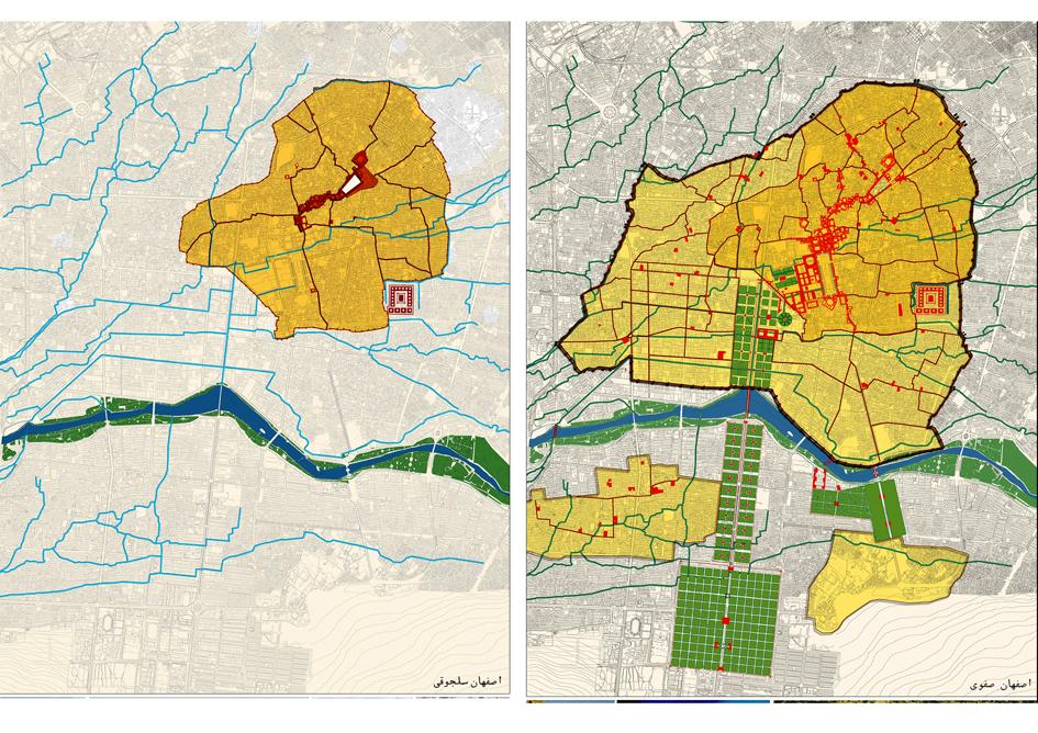
From 1590/1 onwards, the city of Isfahan was transformed in a magnificent royal building programme. The dense urban agglomeration that had grown up since the tenth century was substantially extended and remodelled. Shah Abbas the Great[1] oversaw an architectural revolution in which grand structures promoted local and international commerce and splendid new leisure amenities were erected. Glorious new mosques acted as part of the royal programme to popularise the Shia approach to Islam.
The new city accommodated a new population. Tabrizis and Armenians – forcibly deported from elsewhere in the Safavid Empire – were housed in purpose-built new suburbs[2]. The newest elite, the gholams, constructed stately residences in innovative and “upscale” neighbourhoods[3]. Large numbers of non-Persians, especially Indian merchants, flocked to do business in the expanded bazaar[4].
Travellers from Western Europe were also increasingly tempted by the local economic and political opportunities. Although absolute numbers remained relatively small, the “trickle” of European visitors became a “flood” after 1600[5]. As reports of their journeys were published, Isfahan – the new capital of Iran, the ‘City of Rule’ – metamorphosed in Western eyes from a “fabled realm” into a place increasingly described in empirical and even panoramic ways[6].
[1] ‘Abbas’ and ‘the Shah’ are used interchangeably here for Shah Abbas the First, also named as ‘Shah Abbas the Great’.
[2] Tabrizis and Armenians. Sussan Babaie et al, Slaves of the Shah (IB Tauris: London, 2004), 87
[3] Babaie, Slaves of the Shah, 88
[4] There were especially large numbers of Indian merchants: the formulaic number of 10,000 was repeated by Chardin, and Kaempfer, as well as an Astrakhan Indian merchant. Stephen F. Dale, Indian Merchants and Eurasian Trade, 1600-1750 (Cambridge: Cambridge University Press, 2002), 66-67.
[5] Rudi Matthee, “The Safavids under Western Eyes: Seventeenth-Century European Travelers to Iran,” Journal of Early Modern History 13 (2009): 138
[6] Matthee, “The Safavids under Western Eyes,” 142

Hi,
You have some interesting material in https://carolinemawer.com/in-depth/safavid-isfahan/isfahan-is-half-the-world-they-say-but-by-so-saying-they-only-go-half-the-way/ and I am very interested on the map comparing pre-Safavid and late-Safavid Isfahan.
is it showing the actual location of a city wall or it is just an imaginary location of Isfahan urban area?
Would you please send me the source.
Regards,