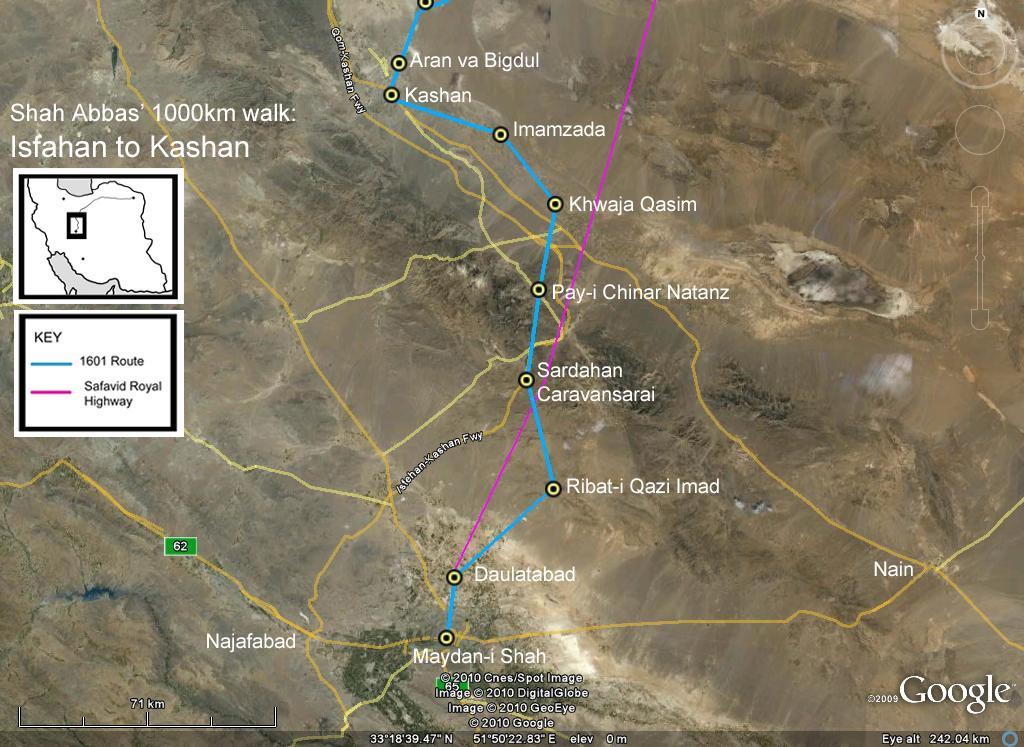
Up through Kashan

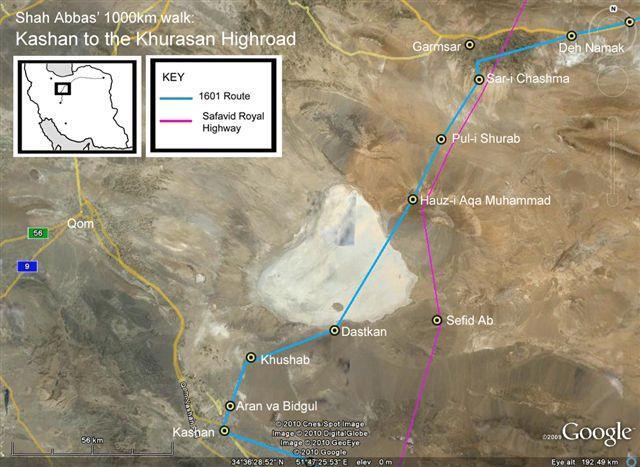
After Kashan (211km from Isfahan), the Shah travelled up to the salt plain of the Darya Namak (white patch on the satellite image here), and then across 40km of salt mud towards the Khurasan Highroad and the holy city of Mashhad.

Up through Kashan

This man is a Qasim, and a descendant of the Hajji/Khwaju Qasim who built the birka (small reservoir) where Shah Abbas halted (159km from Isfahan). He has distinctively hazel eyes (sadly not shown at their best here in the bright midday sun), and all his relatives – perhaps including Khwaju Qasim, over four hundred years ago – …

See more

Up through Kashan

Although not as large as the one which sheltered Shah Abbas, the chenar (plane tree) partly shown here in front the Natanz shrine is still a mighty tree. Its shade is probably one of the reasons why the luscious colours still remain on the early fourteenth century tiles on the portal.

Up through Kashan

This satellite image of Natanz shows the main street, lined with plane trees (chenar). The Ilkhanid shrine of Abd al-Samad – and even the shadow of its’ lofty minaret – is easily visible. The ‘monstrous’ chenar under which Shah Abbas lodged (123km from Isfahan) is now only a struggling stump: Figueroa described it in 1618 as easily …

See more

Up through Kashan

Sardahan is one of the few caravanserais ever to be marked on maps. Siroux describes it as a “lost Italianate palace, rich in theatrical effects” – and even its ruins are still splendid.

Up through Kashan

This satellite image shows the Sardahan pass. The caravanserai remains (87km from Isfahan on Shah Abbas’ 1601 walk) are near the modern road.

Up Through Kashan

Older men in villages were both helpful and knowledgeable when I was looking for specific stopping places. This man, shown here with his wife, helped me find the Sardahan caravanserai.

Up through Kashan

This schematic drawing shows the first part of Shah Abbas’ 1601 walk (bigger dots), as well as the later Safavid Royal Highroad (small dots) up to the palaces in Mazanderan.

Up through Kashan

This satellite image shows the first part of Shah Abbas’ walk (blue line) – up to Kashan. The ziggle to Ribat-i Qazi Imad may be because of marshy ground north of Isfahan (labelled as the Maydan-i Shah). Abbas was then guided across 30km of fearsome salt desert, using pillars of black stones; before embarking across …

See more

Starting from Isfahan

Near the site of Masjid-i Tuqchi was the Qushkane or Aviary Gardens, the site for the reception of dignitaries and ambassadors arriving in Isfahan. It is now the public ‘Park of the Birds’.